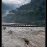
On June 1, 2025, a devastating landslide struck Lachen, a remote Himalayan town in Sikkim, burying homes and cutting off access to rescue teams. The disaster left authorities scrambling to locate survivors and recover the missing, amid unstable terrain at 12,000 feet above sea level. Traditional search methods, including thermal cameras and sniffer dogs, struggled to operate effectively in the harsh conditions.
Then, within 24 hours, the Indian Army turned to an unexpected solution: a drone equipped with Ground-Penetrating Radar (GPR) developed by Bhubaneswar-based startup BonV Aero. The drone’s subsurface scanning capabilities detected two anomalies, 0.76 meters and 0.015 meters deep, leading excavators directly to human remains. This marked one of the first successful uses of GPR drones in high-altitude disaster response, setting a new precedent for rescue operations worldwide.
The Drone That “Sees” Underground
Unlike standard drones that rely on cameras, BonV Aero’s UAV uses radio waves to penetrate debris, mapping density changes beneath the surface. The technology, initially designed for military and mining applications, was adapted for search and rescue (SAR) after the company recognized its potential in disaster zones.
How It Works:
-
The drone emits electromagnetic pulses into the ground.
-
Signals bounce back differently when they hit objects (like rocks vs. human remains).
-
Data is transmitted in real-time to a digital map, allowing ground teams to pinpoint excavation sites.
In Sikkim, the drone’s findings were confirmed within hours, eliminating the need for risky, large-scale digging. “The Army’s decision to deploy our system allowed for focused, efficient recovery,” said BonV Aero CEO Satyabrata Satapathy.
Why This Mission Was Unlike Any Other
-
Altitude Challenges:
Most drones struggle in thin air, but BonV’s UAV tested at 19,024 feet in Ladakh maintained stability despite Lachen’s 12,000-foot elevation. -
Speed of Deployment:
The drone was mobilized within a day, a critical factor in SAR where delays reduce survival odds. -
Precision Over Guesswork:
Traditional methods often require excavating large areas, which wastes time and risks secondary collapses. The GPR drone narrowed the search to two exact locations, saving hours of labor.
The Bigger Picture: Drones Redefining Disaster Response
The Sikkim operation highlights a global shift toward AI and UAVs in emergencies:
-
Nepal (2023): Drones mapped earthquake damage in minutes, guiding rescuers to blocked roads.
-
USDA (2024): LiDAR drones assessed landslide risks in Mississippi, slashing survey times by 80%.
Yet challenges remain:
-
Battery Life: Most commercial drones have a battery life of 30–40 minutes, which limits their range.
-
Regulation: Strict airspace laws in urban areas delay deployments.
BonV’s solution? Heavy-lift drones with extended flight times, already proven in Ladakh with 30 kg payloads at 19,000 feet.
What’s Next for Rescue Tech?
The Indian Army plans to integrate more GPR drones into its disaster-response units. Meanwhile, BonV Aero is refining its platform for earthquake and avalanche detection, where subsurface detection could save thousands.
“The future isn’t just about flying higher, it’s about seeing deeper,” said CTO Abinash Sahoo.