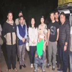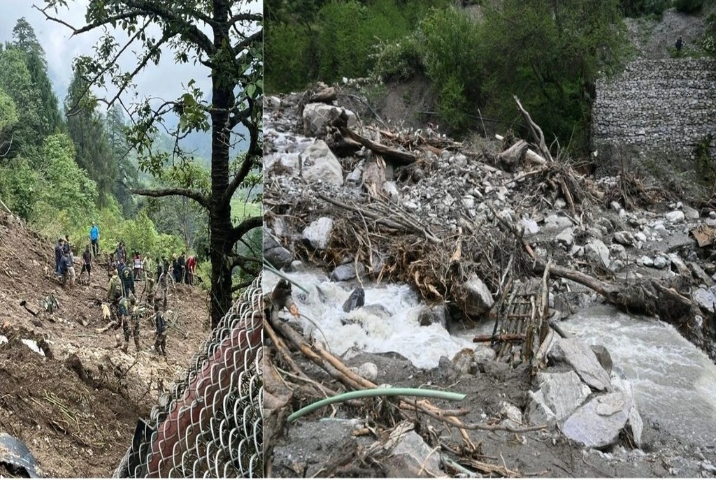
On June 1, 2025, a landslide triggered by relentless monsoon rains slammed into Chaten, North Sikkim, burying an Army camp and severing Lachen, the region’s tourism hub, from the rest of the state. With roads destroyed and bridges washed away, 113 tourists, including two U.S. nationals, were trapped in the remote valley. What followed was a high-stakes rescue mission combining ground grit and aerial precision, orchestrated by the Indian Army and Air Force under near-impossible conditions.
The Crisis Unfolds: Lachen’s Isolation
The landslide, which struck at 7 PM on June 1, killed three Army personnel and left six missing, including Lieutenant Colonel Pritpal Singh Sandhu and his family. Lachen, a picturesque village nestled at 8,500 feet, was cut off entirely. Tourists recounted watching the sole highway vanish under rubble. “We had no signal, no way out, just mountains closing in,” said a rescued traveler via social media.
Key Challenges:
- Terrain: Steep slopes and unstable debris made ground access lethal.
- Weather: Continuous rain grounded helicopters for 48 hours.
- Infrastructure: Two critical bridges over the Taran Chu River collapsed, blocking motorized evacuation.
Boots on the Ground: Engineering Hope
With aerial rescues stalled, the Army’s engineering corps carved a 15-km footpath through landslide debris in 36 hours. Teams carried satellite phones and medical kits, delivering 2.5 tons of supplies to stranded groups. “We used ropes and makeshift bridges; every step was a risk,” said an NDRF officer. By June 3, all 109 tourists in Lachen had been moved to Chaten’s Army camp, where they awaited airlift number.
Critical Numbers:
- 30 NDRF personnel deployed via helicopter with emergency gear.
- 200+ Army troops involved in ground operations.
- 85% of rescues were completed within 72 hours, faster than the 2023 Himachal floods.
Sky Heroes: IAF’s High-Risk Airlifts
On June 3, a brief weather window allowed two Mi-17V5 helicopters to take off from Pakyong Airport. Pilots navigated 60-knot winds to land on makeshift clearings near Chaten. The first sortie airlifted 34 tourists, including the U.S. nationals, to safety. “Flying blind through cloud walls is the new normal,” said Major Arjun Singh, an IAF pilot.
Airlift Stats:
- 12+ sorties in 48 hours.
- 113 tourists evacuated by June 4.
- 2.5 tons of supplies delivered via air.
The Human Network: Coordination Against Chaos
A “war room” in Gangtok coordinated efforts between the Army, NDRF, Sikkim Disaster Response Force (SDRF), and Border Roads Organisation (BRO). AI-powered hazard maps predicted secondary landslides, while social media monitoring located stranded groups. Chief Minister Prem Singh Tamang declared the situation a “disaster” under national law, unlocking emergency funds.
Tech Edge:
- Satellite phones ensured communication in areas with no cellular coverage.
- Real-time drone footage guided route clearance by BRO.
Voices from the Ground: Survivor Stories
- “Soldiers carried my daughter on their backs for miles,” said a rescued mother.
- “We saw death, then we saw heroes,” recounted a tourist from Kolkata.
Why This Rescue Redefines Disaster Response
- Cascade Mitigation: Preemptive mapping of landslide-flood chains, a tactic borrowed from Nepal’s multi-hazard frameworks.
- Tourist-Centric DRR: Equal priority for visitors and locals, aligning with global Sendai Framework benchmarks.
Lessons for Travelers & Policymakers
- For Tourists: Monsoon travel in the Himalayas requires GPS beacons, not just phones.
- For Governments: Invest in military-civilian disaster playbooks and satellite internet for remote areas.
Conclusion: The Unfinished Mission
As of June 4, all tourists are safe, but six remain missing. “Every life matters,” the Army reiterated, deploying specialized teams to comb the unstable terrain. For Sikkim, the disaster underscores the price of climate volatility and the valor of those who fight it.