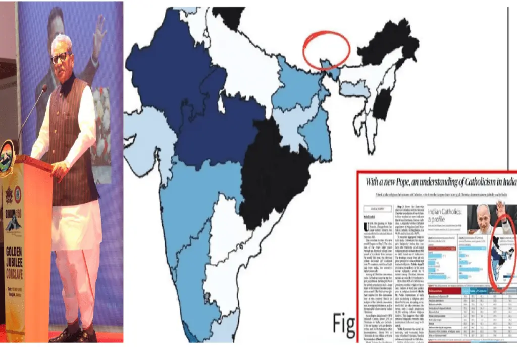
Sikkim Governor Om Prakash Mathur has strongly criticized The Hindu newspaper for publishing a map of India that excluded the northeastern state of Sikkim. The error, which appeared in the May 13, 2025, edition, has triggered widespread anger among politicians and citizens, especially as Sikkim prepares to celebrate its 50th anniversary of statehood on May 16.
“This is not a mere oversight; it is a betrayal of Sikkim’s place in India,” Governor Mathur said in a public statement. The controversy has reignited debates over media responsibility, national sovereignty, and the importance of accurate cartography in a politically sensitive region.
Why This Map Mistake Matters
Sikkim, a small but strategically vital state bordering China, became part of India in 1975 under a special constitutional provision (Article 371F). The omission of Sikkim from an official map is not just a technical error, it raises concerns about territorial integrity at a time when border disputes with China remain unresolved.
Chief Minister Prem Singh Tamang called the mistake “unacceptable” and demanded an immediate correction. The Bharatiya Janata Party (BJP) ‘s Sikkim unit also condemned the error, calling it “an insult to the people of Sikkim.”
How the Controversy Unfolded
- The Incorrect Publication
- On May 13, The Hindu printed a map of India in its newspaper that did not include Sikkim.
- The error was quickly spotted by readers, who shared images on social media with the hashtag #SikkimExists.
- Political Backlash
- CM Tamang accused the newspaper of undermining India’s sovereignty.
- Governor Mathur, a former BJP leader, called for stricter media guidelines on map accuracy.
- The BJP’s Sikkim unit demanded an official apology and a government inquiry.
- Public Reaction
- Protests erupted in Gangtok, with students holding signs reading, “We Are India Too.”
- Online petitions calling for legal action against The Hindu gained thousands of signatures.
Historical Context: Sikkim’s Unique Status
Sikkim was an independent kingdom until 1975, when it joined India under a special agreement. Article 371F of the Indian Constitution protects Sikkim’s land laws and cultural identity.
- Strategic Importance: Sikkim shares a border with China’s Tibet region, making it a sensitive zone in India-China relations.
- Recent Tensions: In 2020, clashes between Indian and Chinese troops occurred near Sikkim’s Nathu La pass.
Experts say that omitting Sikkim from maps, intentionally or not, could weaken India’s territorial claims in future disputes.
Media Accountability: Should There Be Penalties for Map Errors?
This is not the first media outlet to misrepresent India’s borders. In 2021, the BBC faced criticism for showing incorrect Kashmir boundaries.
- Legal Consequences: India’s Geospatial Information Regulation Act (2016) mandates fines or jail for incorrect maps, but enforcement is rare.
- Ethical Responsibility: Should newspapers face stricter penalties for cartographic mistakes? Legal experts are divided.
The Hindu has not yet issued a public apology but is expected to release a corrected version soon.
What Happens Next?
- Government Response
- The Ministry of Information and Broadcasting may investigate the incident.
- Governor Mathur has urged central authorities to enforce stricter map-verification rules.
- Public Awareness
- Sikkim’s government plans educational campaigns highlighting the state’s history and constitutional rights.
- Diplomatic Implications
- China, which has previously questioned Sikkim’s status, could exploit the error in future negotiations.
Conclusion: A Fight for Recognition
The missing map controversy is more than a printing mistake, it’s a reminder of how easily geography can become political. As Sikkim marks 50 years as part of India, Governor Mathur’s strong stance sends a clear message: “Sikkim will not be erased.”
For now, all eyes are on The Hindu’s next move and whether this incident will lead to lasting changes in how India’s borders are represented.